Plan de Corones > Passo Furcia

Add to favourites
Category
Difficulty
Easy
Duration
1:30
in hours
Distance
3.3
in km
Suggested period
Jan
Feb
Mar
Apr
May
Jun
Jul
Aug
Sep
Oct
Nov
Dec

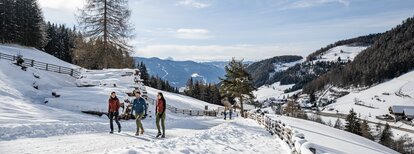
Medium-difficult hike with marvellous views from the peak out onto the surrounding mountains.

Route data
Easy
Distance
3,3 km
Duration
1 h 30 min
Ascent
5 m
Decent
529 m
Physical condition
Scenary
Highest point
2.270 m
Lowest point
1.740 m
Directions
The hike starts at the summit of Kronplatz. From there, follow trail no. 1 on a well-signposted path to the Furkelpass.
The hike can also be done in reverse, i.e. you start at Furkelpass and reach the summit of Kronplatz. Here too, always follow the number 1 signs.
How to get there

To get there, drive to Passo Furcia-Furkelpass via Valdaora-Olang or San Vigilio-St. Vigil and park your car directly at the mountain pass.

You might be interested in
Discover related tours
Bruneck and surroundings
Lanebach
Distance 3,6 km
Duration 2 h 05 min
Ascent 662 m
Decent 0 m
Status
closed
Bruneck and surroundings
Hiking tour to the Walder Alp Hut
Distance 1,6 km
Duration 1 h 00 min
Ascent 370 m
Decent 3 m
Wandern | © (c) Manuel Kottersteger, Olang
Intermediate
Add to favourites
Bruneck and surroundings
Geiselsberg - Bruneck
Distance 11,5 km
Duration 3 h 08 min
Ascent 227 m
Decent 741 m
Bruneck and surroundings
Hike through the "LandArt" trail
Distance 2,3 km
Duration 37 min
Ascent 36 m
Decent 49 m
Bruneck and surroundings
Bad Bergfall - Kronplatz
Distance 4,9 km
Duration 3 h 00 min
Ascent 957 m
Decent 2 m
Bruneck and surroundings
Gaisinger "Waalweg"
Distance 5,3 km
Duration 2 h 00 min
Ascent 140 m
Decent 140 m