Panoramic trail Pfalzen / Falzes

Bruneck and surroundings
Add to favourites
Category
Difficulty
Easy
Duration
2:00
in hours
Distance
5.2
in km
Suggested period
Jan
Feb
Mar
Apr
May
Jun
Jul
Aug
Sep
Oct
Nov
Dec
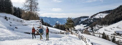
This pleasant hike above Pfalzen leads through meadows and along the edge of the forest, passes wayside crosses, chapels and farms and offers a beautiful view on the village and the Kronplatz.
Tags
  • Family-friendly
Route data
Easy
Distance
5,2 km
Duration
2 h 00 min
Ascent
189 m
Decent
189 m
Physical condition
Scenary
Highest point
1.194 m
Lowest point
1.027 m
You might be interested in
Discover related tours
Wandern | © (c) Manuel Kottersteger, Olang
Intermediate
Add to favourites
Bruneck and surroundings
Geiselsberg - Bruneck
Distance 11,5 km
Duration 3 h 08 min
Ascent 227 m
Decent 741 m
Bruneck and surroundings
St. Lorenzen/San Lorenzo – Maria Saalen/Maria Sares
Distance 4,9 km
Duration 1 h 00 min
Ascent 170 m
Decent 6 m
Welsberg Monguelfo | © TG Gsiesertal Welsberg Taisten_Kamilla Photography, Dolomite Region Gsiesertal Val Casies
Intermediate
Add to favourites
Bruneck and surroundings
Camino de Santiago, stage Monguelfo – Valdaora – Nessano – Brunico
Distance 21,2 km
Duration 5 h 51 min
Ascent 441 m
Decent 695 m
Aschbach Alm hut and Redensberg Alm hut | © Schuster Barbara, Tourismusverein Antholzertal
Intermediate
Add to favourites
Bruneck and surroundings
Aschbach Alm hut and Redensberg Alm hut (not managed)
Distance 3,4 km
Duration 1 h 52 min
Ascent 578 m
Decent 7 m
Status
closed
Bruneck and surroundings
Hike to the "Mühlbacher Badl"
Distance 1,0 km
Duration 23 min
Ascent 103 m
Decent 0 m
Bruneck and surroundings
Hiking tour to the Walder Alp Hut
Distance 1,6 km
Duration 1 h 00 min
Ascent 370 m
Decent 3 m