City & Highlights


Tales and stories of Mount Kienberg
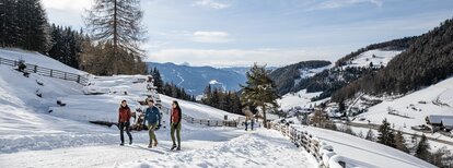
With its 1222 m, Mount Kienberg stands out from its surroundings like an island. A plutonic rock formed during the creation of the Alps, it emerged from the heart of the earth only to be smoothed down by passing glaciers over the course of countless years. Today, Kienberg is a broad, rotund ridge shrouded in legends: The hike along the Kienberg trail from Casteldarne/Ehrenburg to Mantana/Montal runs past the Plattnerhof farm. Legend has it that once upon a time, it was the home of a stone-hearted man. One day, the farmer chased away a hungry beggar with nothing but insults and threats, upon which the beggar cursed the mountain, making all its springs run dry.
After a short break at the hamlet of Mantana/Montal, the hike runs back to Casteldarne/Ehrenburg along an old trail depicting the Stations of the Cross. Every year, pilgrims from Predoi/Prettau in the Aurina/Ahrntal valley flock here to ask the Madonna of the Grains to bless their home and livestock and to grant their fields favorable weather.
The highest point of the ridge is 1222 m above sea-level. This hike is ideal for those who love quiet trails far from the beaten track. Stop for a break at Gasthof Alpenrose (Mantana/Montal), Hofschenke Lerchner's (Ronchi/Runggen), or Gasthof Obermair.
Ehrenburg - Parking next Koflerhof