
Hike to the "Mühlbacher Badl"

Bruneck and surroundings
Add to favourites
Category
Difficulty
Easy
Duration
0:23
in hours
Distance
1
in km
Suggested period
Jan
Feb
Mar
Apr
May
Jun
Jul
Aug
Sep
Oct
Nov
Dec

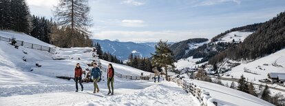
The hike to Mühlbacher Badl starts at the Mühlbachtal parking lot and follows trail no. 2. The leisurely walk takes about 30 minutes and leads through the picturesque Mühlbachtal, accompanied by the soothing sound of the stream. At the end of the trail, you reach Mühlbacher Badl, a charming spot perfect for relaxing and unwinding. This short but rewarding hike is ideal for those who enjoy nature and tranquility.

Route data
Easy
Distance
1,0 km
Duration
23 min
Ascent
103 m
Decent
0 m
Physical condition
Scenary
Highest point
1.695 m
Lowest point
1.591 m
How to get there

Coming from Innsbruck/Brenner (A): Drive on the Highway of Brenner (A22) until the exit Brixen/Pustertal, then go on along the SS49-E66 for about 50kms until you arrive in Olang/Valdaora.

Coming from Lienz (A): You can reach us also padding by Lienz in Westtyrol (A). You have to cross the Austrian-Italian border between Ahrnbach and Winnebach (B100-E66) and drive on the SS46-E66 until Olang/Valdaora

Coming from Bozen: Highway of Brenner (A22) until the exit Brixen/Pustertal, then go on along the SS49-E66 for about 50kms until you arrive in Olang/Valdaora.

You might be interested in
Discover related tours
Bruneck and surroundings
Hiking to the Lercher Alp Hut
Distance 2,4 km
Duration 2 h 00 min
Ascent 243 m
Decent 0 m
Aschbach Alm hut and Redensberg Alm hut | © Schuster Barbara, Tourismusverein Antholzertal
Intermediate
Add to favourites
Bruneck and surroundings
Aschbach Alm hut and Redensberg Alm hut (not managed)
Distance 3,4 km
Duration 1 h 52 min
Ascent 578 m
Decent 7 m
Bruneck and surroundings
Hiking Trail Haidenberg
Distance 2,0 km
Duration 1 h 00 min
Ascent 343 m
Decent 0 m
Kofler am Kofl | © Thomas Conti, Bruneck Kronplatz Tourismus
Intermediate
Add to favourites
Bruneck and surroundings
Kofler am Kofl
Distance 2,5 km
Duration 1 h 30 min
Ascent 360 m
Decent 0 m
Plan de Corones > Passo Furcia
Distance 3,3 km
Duration 1 h 30 min
Ascent 5 m
Decent 529 m
picnic area | © Tourismusverein Kiens, Kiens
Intermediate
Add to favourites
Bruneck and surroundings
Culture and landscapes
Distance 12,1 km
Duration 3 h 27 min
Ascent 341 m
Decent 341 m