

Art along the way - Moarberger pond

Bruneck and surroundings
Add to favourites
Category
Difficulty
Easy
Duration
0:12
in hours
Distance
0.8
in km
Suggested period
Jan
Feb
Mar
Apr
May
Jun
Jul
Aug
Sep
Oct
Nov
Dec

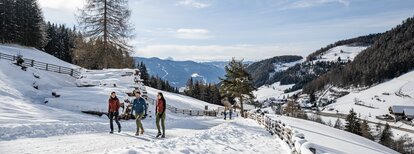
Extraordinary art objects have been incorporated into the picturesque backdrop of the hiking trails of Reischach/Riscone, which sometimes only the attentive hiker can see.

Route data
Easy
Distance
0,8 km
Duration
12 min
Ascent
12 m
Decent
21 m
Physical condition
Scenary
Highest point
921 m
Lowest point
907 m
Suggestions
As the hiking trails can be icy, it is advisable to use microspikes.
Directions

The art path leads along the southern bank of the "Moarberg" pond, which you can reach either from Bruneck via "Waldheim", as well as via "Kaiserwarte - path no. 21 A - or from the street "Reischacherstraße", below the bar/pub Sport's Arena, along path no. 21C.

How to get there
Public transport from Mobility Center Bruneck/Brunico:
With the Citybus 420.1 to Reischach/Riscone, bus stop "Feldweg/Via dei Campi".
You might be interested in
Discover related tours
Bruneck and surroundings
Hiking tour to the Earth pyramides
Distance 3,1 km
Duration 1 h 30 min
Ascent 152 m
Decent 152 m
Hasenried | © Klara Oberlechner, Bruneck Kronplatz Tourismus
Intermediate
Add to favourites
Bruneck and surroundings
Four Churches Trail - variant St Martin church in Hofern
Distance 10,1 km
Duration 3 h 02 min
Ascent 409 m
Decent 192 m
St. Valentin | © Klara Oberlechner, Bruneck Kronplatz Tourismus
Intermediate
Add to favourites
Bruneck and surroundings
Four Churches Trail - variant bus stop Hofern
Distance 8,5 km
Duration 2 h 24 min
Ascent 233 m
Decent 200 m
Bruneck and surroundings
Art along the way - Panorama path
Distance 0,9 km
Duration 19 min
Ascent 68 m
Decent 0 m
Bruneck and surroundings
The "Maurach" Trail (Element paths)
Distance 2,7 km
Duration 44 min
Ascent 33 m
Decent 31 m
Gais-Uttenheim | © @BruneckKronplatzTurismus, Bruneck Kronplatz Tourismus
Intermediate
Add to favourites
Bruneck and surroundings
The Valley Floor Trail from Gais via Uttenheim to Mühlen (Element paths)
Distance 5,8 km
Duration 1 h 41 min
Ascent 190 m
Decent 135 m